Posts

Boston: Phillips School

Image
Last week we learned about George Middleton and I mentioned that one of the causes he supported was that of equal education rights.  Throughout the majority of Boston's history schooling was racially segregated, as it was across most of America.  One of the most visible symbols of that struggle, and the eventual success that was found from years of effort, is the Phillips School. Originally built in 1824, the school on the corner of Pinckney and Anderson Streets first housed the English High School - America's first public high school, which had been founded just three years earlier.  The school only admitted white males, although a school for girls was also established in 1824.  By 1844, English High School had moved to downtown Boston (next to Boston Latin School), and the building in Beacon Hill was converted to a grammar school.  The new Phillips Grammar School was named after Boston's first mayor, John Phillips, and remained a white-only school because all ...

Boston: George Middleton House

Image
If you take up arms to fight for the freedom of a nation, what sort of personal freedom do you expect in return?  This week we take a look at the home of a man who answered that very question.  Like several homes along the Black Heritage Trail, the building at 5 Pinckney St. in Beacon Hill is a private residence today and is therefore not available for touring, but the site remains an important one for the community. George Middleton was approximately 40 years old when the first shots of the American Revolution were fired.  Born at some point in 1735, the exact month and day are unknown.  He chose to fight alongside his countrymen as a Patriot against the British, and was in command of a unit that was known as the Bucks of America.  This group was one of very few all-black companies in Massachusetts during the American Revolution, and although war records are incomplete and do not detail what action they saw, it is believed that Middleton (the only member of the...

Boston: 54th Regiment Memorial

Image
At the edge of Boston Common, directly across Beacon Street from the Massachusetts State House, stands a bronze memorial set in marble.  The image depicts a single mounted officer alongside his marching troops - the men who, at this very location, marched into history on May 28, 1863.  It is Colonel Robert Gould Shaw leading his men to war, and those troops are the 54th Regiment Massachusetts Volunteer Infantry.  The Civil War began in the spring of 1861, and within a week of the first shots being fired at Fort Sumter, SC, a young man from a wealthy Boston family had enlisted to serve in the Union army.  Within 18 months, young Robert Gould Shaw had fought in several battles (including Antietam), been wounded twice, and had been promoted from private to second lieutenant to captain.  Any cause for celebration that his upward mobility provided, however, would likely have been tempered by the relative lack of success for the Northern troops.  A war that both ...

Boston: Black Heritage Trail

Image
Did you know that Boston has additional trails to travel?  Does it surprise you that they have one dedicated to the city's African American population?  A city that prides itself on being the Cradle of Liberty nevertheless has a complicated history for minorities, and the Black Heritage Trail that branches off from the Freedom Trail between Boston Common and the Massachusetts State House serves to inform visitors about that past. Boston's history with the black community goes back almost as far as that of its European inhabitants.  The first recorded landowner of African descent within modern Boston's city limits was Bostian Ken.  His home (and at least four acres of land) were purchased in 1656 as part of Dorchester, a town just south of the city that was annexed by Boston in 1870.  A former slave himself, Ken actually mortgaged his property to purchase the freedom for another slave for the sum of 32 pounds - a move that also earned him the designation as the f...

Boston: Freedom Trail Recap & Skinny House

Image
And so we've come to the end of the Freedom Trail.  This set of 16 sites has helped define one of the most significant cities to our nation's history.  But we are not finished with the town itself, because as time has passed Boston has continued to reinvent itself into the city of today. As we move into the next several weeks, we're going to look at many of these additional sites that make Boston what it is today, as well as dig more deeply into the physical changes of the city itself.  Just for fun this week, I thought it might be enjoyable to spend a minute looking at a small-but-interesting location that has become iconic for citizens.  The Skinny House, located in Boston's North End across the street from Copp's Burying Ground, is a famous spite house - one built not for function, but for anger or revenge.   Measuring roughly 10 feet wide and 30 feet long, this four-story home constructed in 1884 sits on a mere 0.03 acres.  The common rumor is that...

Boston: Bunker Hill Monument

Image
It is fitting that we come to the end of the Freedom Trail in Boston at Bunker Hill this week.  The skirmishes along the roads to Lexington and Concord may have provided the first armed conflict of the American Revolution, but the Battle of Bunker Hill was the first organized battle of the war.  It is seemingly appropriate that we close out Memorial Day weekend at the location of the memorial to our nation's first soldiers.  Lexington, Concord, and Bunker Hill cost 164 American lives - the first military blood spilled in the struggle to create the nation we call home. The Bunker Hill Monument is a stone obelisk rising 221 feet above...Breed's Hill.  That's right, most of the fighting occurred, and the memorial is therefore placed, upon Breed's Hill.  The battle itself was named after another hill north of Charlestown, which is where the commanders of the Colonists (Colonel William Prescott and General Israel Putnam) were initially ordered to secure.  ...

Boston: USS Constitution

Image
This week we cross the water where the Charles River empties into Boston Harbor, much as Paul Revere did all those years ago.  Our destination is the oldest commissioned naval vessel in America (and oldest currently afloat in the world), USS Constitution - a ship that was built, interestingly, using fastening bolts and copper sheathing provided by Revere himself!  She resides in the Charlestown Navy Yard as the namesake of the USS Constitution Museum, and is still crewed by naval officers to "preserve, protect and promote" both her and the U.S. Navy. When Americans finally achieved independence, it became clear that a naval presence would be necessary to protect the assets and interests of the fledgling nation.  After the Continental Navy was disbanded following the war, the remaining ships had been sold to help pay debts (although only 11 of the original 65 boats had survived the war).  Launched in 1797 from Edmund Hartt's shipyard in Boston, USS Constitution r...

Boston: Copp's Hill Burying Ground

Image
The third and final cemetery along the Freedom Trail sits near the northern end of the city, and is the second-oldest burial site in Boston.  Copp's Hill Burying Ground is the final stop of the Freedom Trail that sits on the Shawmut Peninsula, the original extents of the city, and is perched on one of three hills that rise above the surrounding land and harbor.  Formerly known as the North Burying Ground, this plot of ground has served as the final resting place of Boston residents since 1659 and is the largest of the town's colonial cemeteries. Copp's Hill was a tactically important location for the British during the American Revolution, as it provided a vantage point from which cannon could be fired towards Charlestown across the river.  During the Battle of Bunker Hill, artillery posted at this location fired on colonial fortifications atop Breed's Hill, apparently to little effect.  It is said that British infantry used the grave markers within the Copp's Hil...

Boston: Old North Church

Image
From the high steeple to the underground crypts, this week's stop along the Freedom Trail has history from top to bottom.  And from the sweet colonial chocolate to a spicy controversy, there remain plenty of delicious reasons to visit.  The Old North Church remains a house of worship and one of the most-visited historical locations in Boston. Standing longer than any church in town since its construction in 1723, "Old North" was officially named Christ Church in the City of Boston.  There were actually two different locations known as "Old North" - in addition to Christ Church, there was also a Congregationalist meeting house that was led by such men as Increase Mather (note that I've corrected my error from last week mistaking these two!).  The second church was torn down by the British in 1775 for firewood, and there are some who believe that structure, which stood diagonally across the street from Paul Revere's home, was the real location of the lan...

Boston: Paul Revere House

Image
This week's stop along Boston's Freedom Trail is our first location within the downtown district.  In fact, it is now the oldest building still remaining in downtown Boston, having been built in 1680.  And because it is a home (the only one along the Freedom Trail) it gives us a unique look at life during the American Revolution - the life of a citizen, a businessman, and a patriot. The address is 19 North Square and, while the building is old, it had an interesting history prior to the construction of the current structure.  From 1670-1676 the site was home to the famous theologian Increase Mather, who was influential to the city as the minister of Second Church as well as later becoming the president of Harvard.  A fire destroyed the original house, but a new one was built by a new owner just a few years later.  Robert Howard was a wealthy merchant who purchased the land from the church and had a two-story townhouse constructed (and I will later point you to...

Boston: Faneuil Hall

Image
The 11th stop along Boston's Freedom Trail encompasses much more than a single building - Faneuil Hall is now surrounded by a number of statues and structures that help tell the story of its history and ensure its neighborhood's future.  Named for the man who funded construction and gave it to the city, merchant Peter Faneuil (pronounced FAN-yull), it originally represented something of a disputed compromise.  The plan was to create a marketplace for the town but such a "gift" was met with some resistance, perhaps because of the thought that such a commercial endeavor would primarily enrich the benefactor, or perhaps because one of his trades was slavery.  The promise of a public meeting space to occupy the second floor was, however, quite appealing and managed to carry the vote.  By the narrow margin of 367-360 the proposal was accepted and Faneuil Hall was opened in 1743 as a central market house and open forum for assembly. During Revolutionary times the town go...

Boston: The Boston Massacre Site

Image
On March 5, 1770 the relationship between Boston and Britain changed forever.  In the shadow of the Old State House, tensions boiled over between a gathering mob of citizens and the soldiers of the 29th Regiment.  Insults were exchanged, challenges were issued, objects were thrown, and eventually shots were fired.  Three men were killed at the scene, another succumbed to his injuries the next day, and a fifth died two weeks later.  A sixth victim was seriously injured, crippled, and died ten years later in 1780, purportedly from complications of his wounds.  No British troops were killed, and the event resulted in the arrest of 13 individuals - eight soldiers, an officer, and four civilians.  Today the event is commemorated by a simple cobblestone circle along the sidewalk amidst the towering buildings of downtown Boston. The cause of the outbreak of violence seems to have been primarily centered around the presence of troops within the city.  Th...

Boston: Old State House

Image
We've gone through half of the sites along Boston's Freedom Trail.  Have you learned anything new?  Does anything surprise you about these historic locations?  Obviously nothing replaces seeing these places in person, but if you're too far away with no plans to travel in the near future then I hope the brief posts and links to helpful websites are at least piquing your curiosity to learn more on your own. This week we'll delve into the story of Boston's oldest public building, the Old State House.  You'll probably recall that we've already seen one location with the "State House" designation, which has housed the majority of Massachusetts government operations since 1798.  Once the center of royal authority in Massachusetts (originally known as the Town House after its construction in 1713), this week's focal point is now a museum housing such interesting pieces as the pre-Revolution Royal Governor's chair, tea from the actual Boston Tea ...

Boston: Old South Meeting House

Image
America's most famous party started right here.  This week, we turn our attention to the Old South Meeting House.  When you see the structure, you'll immediately think it looks like a church, and that's because it is.  In colonial times, meeting houses were built with public (tax) money, but served many purposes including regular religious worship.  As early as 1669, the site was home to a wooden Puritan meeting house, known as Boston's "Third Church".  First Church was the original 1630 congregation, started by John Winthrop, followed by Second Church in 1649.  It was in 1729, however, that Third Church was rebuilt in its current brick form as the largest building in Boston. Old South's size made it a perfect location for large segments of society to gather, and this is precisely what began to happen as patriots and loyalists began to choose sides during the pre-Revolution years.  Thousands of citizens would crowd inside to hear orators and deba...

Boston: Old Corner Bookstore

Image
Today we will embark on a study of one of the more complex locations along Boston's famed Freedom Trail.  The modern story of the Old Corner Bookstore actually began in 1634 when William and Anne Hutchinson moved to Boston and built a home on this site.  This same Anne Hutchinson would become famous (or infamous, depending on your viewpoint) for challenging the same Puritan leaders she had followed to the New World, and was both excommunicated and banished from Massachusetts for sedition and heresy in 1638 - where she assisted Roger Williams at the Providence Plantation colony in the creation of Rhode Island.  The original wooden structure was burned along with many others by fire in 1711 but was purchased and redeveloped in brick by Dr. Thomas Crease for the dual use of home and apothecary.  This business is now America's oldest commercial building, as well as one of its oldest brick structures.  Above the first floor, the facade appears nearly the same as it...

Boston: Latin School Site and Benjamin Franklin Statue

Image
Welcome back from our one-week hiatus!  This week we'll delve into the next stop along the famous Freedom Trail, and given that this is the first week back from a school break it seems only fitting that we're discovering the nation's very first public school.  Boston Latin School, founded in 1635, was a place where boys of any social standing could come and learn, although due to its success it has attracted children from the upper echelon of Boston's population.  Still active to this day, although now in a different location, the school's proud motto proclaims "Sumus primi" - We are first. It also boasts quite an interesting history related to the American Revolution.  Five signers of the Declaration of Independence studied at this location, but the only one who didn't graduate is now memorialized on the site with his own statue - Benjamin Franklin was, in fact, a dropout.  A quick study of Franklin's story during the Revolution will show that h...

Happy Spring Break

I'm on vacation with the family this week - wishing everyone a terrific Spring Break, and excited about delving back into the geography and history of Boston soon!

Boston: King's Chapel & Burying Ground

Image
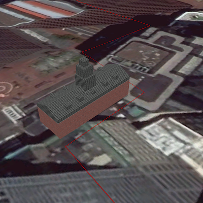
Just as the Granary Burying Ground that was the focal point of our study last week was not affiliated directly with the Park Street Church next door, today's site contains both a chapel and cemetery that are not under common administration.  And as much history as our previous two stops may have provided, neither one can compete with the age of King's Chapel and the King's Chapel Burying Ground.  As Boston's oldest cemetery, this site housed the only burial location in the city for thirty years following its inception in 1630.  Historical individuals such as Mary Chilton (the first woman from the Mayflower to set foot on the New World), John Cotton (a highly-influential 17th century Puritan minister), and John Winthrop (the first colonial governor of Massachusetts) are buried here, but no more than half of the 1,000+ graves on the property have a surviving headstone or footstone.  In the image below, note the proximity and size difference of King's Chapel Burying Gr...

Boston: Granary Burying Ground

Image
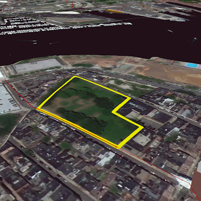
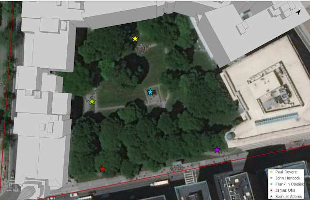
This week's site along the Freedom Trail, although we are once again studying a location that predates the American Revolution, does not necessarily lend itself very well to the 3D mapping that you have seen over the past few weeks.  And that is because, other than the markers that stand along the ground, the primary points of interest lie just a few feet below the surface.  Settled in a plot of land immediately beside the Park Street Church, you will discover the Granary Burying Ground - a cemetery that serves as the final resting place of many of Boston's most famous residents.  Named for the grain storage building that used to sit between it and Boston Common, this 17th-century burial ground contains approximately 2,300 grave markers but is estimated to contain the remains of over 5,000 individuals - hundreds of whom are infants.  In the map below I have added a few markers to help you spot some of the names that may be familiar. As you can see from the leg...

Boston: Park Street Church

Image
I know that last week I mentioned that the State House was one of the few sites that is from after the American Revolution, so it may seem odd that we now turn our attention to a church that was founded some 30 years after the Declaration of Independence was signed.  And yet the Park Street Church remains historically significant for two reasons - first, because it stands on the site of the city's old grain storage, and second, because it is beside next week's focal point, the Granary Burial Ground.  The property, standing just across the street from Boston Common, would have obviously been an important location to the citizens.  Henry James, a famous 19th century writer, regarded Park Street Church as "the most interesting mass of bricks and mortar in America" and from the beginning of the 19th century until shortly after the Civil War its status as the tallest building in town made it the first recognizable landmark that could be seen by visitors to the city of Bost...

Boston: Massachusetts State House

Image
Standing just across the street from Boston Common, which we explored last week, is the Massachusetts State House.  This is one of the sites along our tour that was not in existence at the time of the American Revolution, but stands on Beacon Hill immediately next to the site where John Hancock - the famed signer of the Declaration of Independence and original elected governor of Massachusetts - lived in his luxurious colonial mansion.  Since just prior to the turn of the 19th century, this building has housed the executive and legislative activity of the government of Massachusetts, as Boston has served as the capital of the colony and state since 1632 (and remember, prior to 1820, Maine was part of Massachusetts as well).  If you ever wonder how important the locals believe their government to be, look no farther than the 1858 phrase that referenced this very structure by Oliver Wendell Holmes, Sr.: "Boston State-House is the hub of the solar system."  The poe...

Boston: Boston Common

Image
The first stop along Boston's famous Freedom Trail is Boston Common, the oldest park in the United States.  Dating from 142 years prior to American independence, and just four years after the Puritans first landed in the New World, Boston Common was intended to be a public space for all residents to enjoy and utilize.  Standing on land that the Puritans had purchased from the very first European settler of what is now Boston, a clergyman named William Blaxton (or Blackstone), Boston Common was communally owned by every homeowner in town and was protected against multiple attempts through the years to encroach, divide, or develop the land. By the time of the American Revolution's beginning, the large, grassy area was used for cattle grazing, public speeches and demonstrations, and finally for stationing over 1,700 British troops that had taken control of the city's unruly population.  Their marks on the land included removal of fencing and trees for firewood, and the dig...

Boston: The Freedom Trail

Image
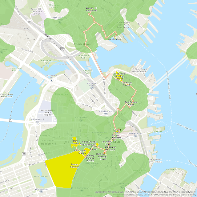
When my wife and I first visited the city of Boston many years ago, we quickly found ourselves on the iconic path that draws millions of tourists each year - the Freedom Trail.  This famous walking tour of Boston, traced by a red path through the city, is among the most important historical markers in the United States and teaches the story of the Revolution by passing 16 important locations.  As each point along the trail is important, I thought it would be nice to wind our way through town one at a time over the upcoming weeks. Today, guides and actors working with the Freedom Trail Foundation help entertain and instruct visitors.  The National Park Service has also designated eight local sites (seven of which are also along the Freedom Trail) collectively as the Boston National Historical Park, and they offer information and assistance of their own. Our own walking tour through the city brought us face-to-face with many of the actual locations where American ...

Boston: Rebels and Patriots

Image
The city of Boston during the latter half of the 18th century was home to many significant characters who would eventually play into the history of American independence.  Samuel Adams, John Hancock, and Paul Revere may today be some of the more memorable characters in the nation's struggle for freedom, but other residents such as James Otis (a passionate and capable speaker who popularized the idea that "taxation without representation is tyranny"), Crispus Attucks (a former slave who helped lead the crowd - and was mortally wounded - during the Boston Massacre), and William Dawes (one of several men to participate in the so-called "midnight ride" that led to the first battle of the Revolution) played key roles as well.  Even the original American "Renaissance Man", Benjamin Franklin, was from Boston and lived there until the age of 17 - and his statue remains to this day in front of their Old City Hall. It should be noted, however, that it is not o...

Boston: A Timeline of Change

Image
As I briefly mentioned in the introduction to this fascinating city, one of the more intriguing aspects to both the history and geography of Boston is the actual land itself.  The original city was a mere 783 acres, and except for a small isthmus (known as the Boston Neck) connecting it to the mainland, it was practically an island lying out in the harbor.  This fascinating map by British engineer and cartographer Thomas Hyde Page (image courtesy of the Library of Congress and now in the public domain) shows the extents of land at the time of the American Revolution. Over the years, much work has been done to fill in many marshy or entirely underwater portions of what used to constitute the Charles River and Boston Harbor.  Here is a comparison of the total land portion of the city, then and now. What a change!  Just as drastic a change occurred to the landscape but is nearly imperceptible when peering down on a map from the top (at least without the aid of...

Boston: A City Overview

Image
Boston is a city that has interested me for quite some time.  Several years ago, my wife and I ventured to New England for our anniversary, and I was able to visit the historic capital of Massachusetts.  As we ventured throughout the city and saw the usual sites, I wondered to myself what this all would've looked like when it was a (comparatively) small city that was home to some of the grandest names in American lore.  As I've indicated before, the study of place is a critical component of my understanding of the study of time: geography helps me know history.  That is the purpose behind the name of this website: Geographist.  And so I began studying the location and reading more about the city.  For those of you who play video or computer games, you may also be familiar with the Fallout franchise - the fourth installment of that series (created by Bethesda Softworks ) is set in the greater Boston area and playing through that game did nothing to dampen my...